Which iOS device should I purchase for Wi-Fi Survey Projects
Updated: Feb 1, 2025, to include the latest iOS devices.
I’m often asked to recommend an Apple device model to support wireless practitioners when performing a Wi-Fi survey or spot-check troubleshooting using Ekahau. This article summarizes the features that should weigh into your consideration of which model to purchase. I provide a table summarizing the models and feature combinations I recommend.
Newer is generally better, but the reality is that cost should be considered. This conversation quickly gets complicated when weighing which features will be used in future projects – not everyone performs outdoor surveys that require GPS.
There are three main technical features to consider; everything else becomes more of a personal preference. These three features are:
- LiDAR
- GPS
- USB-C
What is LiDAR?
LiDAR, or Light Detection and Ranging, is a remote sensing technology that uses light as a pulsed laser to measure variable distances to the Earth. These light pulses—combined with other recorded data — generate precise, three-dimensional information about the objects in an environment and their surface characteristics.
Recent iPad Pro and iPhone models have integrated LiDAR technology to enhance augmented reality (AR) experiences and improve camera capabilities. LiDAR contributes value to iOS devices:
- Enhanced AR Experiences: This allows iOS devices to quickly and accurately map the environment around them, making AR applications more immersive and realistic. It enables better object recognition, improves the placement of virtual objects in the real world, and provides smoother and more accurate motion tracking.
- Improved Photography and Videography: In low-light conditions, LiDAR aids the camera system by providing depth information, which helps focus faster. This capability particularly benefits the Night and Portrait modes, allowing for better separation between the subject and the background.
- Faster and More Accurate Autofocus: By measuring the distance to objects, LiDAR technology enables iOS devices to focus more quickly and accurately, even in challenging lighting conditions. This leads to sharper images and more reliable camera performance.
- 3D Scanning: LiDAR technology enables sophisticated 3D scanning applications on iOS devices. Users can create high-resolution 3D models of objects and spaces around them, opening possibilities for:
- Floor plan creation,
- Topological maps with labels including:
- Floors, walls, ceilings, windows, doors, and cabinets
- Wireless design/ architecture
- Various signal visualization opportunities.
Integrating LiDAR technology into iOS devices enhances their utility in AR applications, improves photography and videography capabilities, and broadens their use in professional and creative contexts. Face ID works similarly as it also shoots out an array of infrared lasers, but Face ID technology can only work up to a few feet away, whereas the rear LiDAR sensor can function at a range of up to 5 meters.
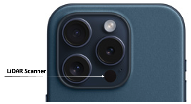
LiDAR is critical for accurate results when using the Autopilot or JustGo survey methods. To know if your iOS device has LiDAR, look closely at the rear camera array for a little black dot near the camera lens, about the size of the flash.
If you aren’t yet convinced about the power of LiDAR enabled apps, checkout what PolyCam 3D LiDAR capturing can do to scan 3D floors plans and create building images. Available for both iOS and Android.
GPS
GPS (Global Positioning System) is a satellite-based navigation system that allows a receiver to determine its precise location (latitude, longitude, and altitude) anywhere on Earth, provided it has a clear line of sight to four or more GPS satellites. For this reason, outdoor GPS surveys are only useful in outdoor environments with clear LoS to the sky. GPS is used for various applications, including navigation, mapping, timekeeping, and search and rescue operations.
Assisted GPS (A-GPS) is a technology designed to enhance the performance of the GPS system, particularly in environments where obtaining a satellite signal can be challenging, such as in urban canyons or indoors. A-GPS uses an internet connection to download data about the approximate location of satellites, helping the device to quickly lock onto satellites by reducing the time it takes to fix the device’s position. This is known as the time to first fix (TTFF).
The main differences between GPS and A-GPS, especially in the context of iOS devices, include:
- Speed of Location Fix: A-GPS can obtain a location fix faster than standalone GPS because it uses additional data from cell towers and Wi-Fi networks to quickly estimate the device’s position before obtaining a precise location from GPS satellites.
- Accuracy in Different Environments: While GPS requires a clear line of sight to satellites, which can be obstructed in urban areas or indoors, A-GPS mitigates this by using assistance data to improve positioning accuracy under such conditions.
- Dependence on Network Connectivity: A-GPS relies on network connectivity to download assistance data, whereas standalone GPS does not require an internet connection to function. However, without A-GPS data, GPS in iOS devices may take longer to acquire a satellite fix, especially if the device has been turned off or moved significantly since its last use.
- Battery Consumption: A-GPS can be more efficient in terms of battery use because it can achieve a location fix more quickly, reducing the time the GPS receiver needs to be active.
In summary, while A-GPS in iOS devices enhance this functionality by using additional data sources to improve the speed and accuracy of location fixes, it does not provide the precision necessary to perform an outdoor survey based on GPS position. As such, the GPS survey method is ONLY supported in LTE-enabled versions of iOS devices. One can create a GPS project on any iOS device as the survey app integrates with Apple Maps, but the survey can only be performed on LTE-enabled iOS devices. As the survey app currently only integrates with Apple Maps, outdoor GPS surveys are not supported on Android.
USB-C
It’s beautiful when all your devices use the same connectors to charge, including your laptop, tablet, smartphone, APoS PoE battery, and Sidekick 2. Keep everything consistent and avoid the need to get lightning to USB-C adapters. Keep your options open with USB-C to USB-C cables that you can order to your preferred length, colour, and jack type. I like to use different colours for different lengths and prefer nylon braids.
Personal Considerations
The following considerations do impact your experience but are not as significant as of the earlier considerations.
Pencil
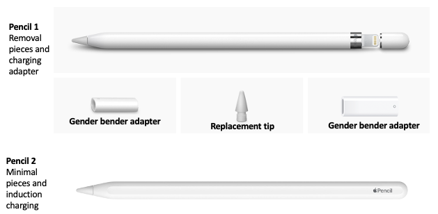
I typically walk around with an iPad strapped to one hand and use a pencil in the other, allowing me to quickly pinch and zoom or pan left or right with a quick swipe. I prefer to use the Pencil 2 over the Pencil as there are fewer pieces to lose. The Pencil 1 has a removable eraser-like tip that, once removed, grants access to a lightning charge port. As the port is the same gender as most lightning charge cables, Pencil 1 includes a gender-bending adapter. If you lose the adapter, you must pay the Apple tax and purchase another adapter. The pencil does not have removable pieces (other than optional replacement tips) and charges using induction when magnetically attached to a compatible iPad. For simplicity reasons, I recommend the Pencil 2.
The Pencil is useful when using the Stop&Go, Continuous, or Autopilot method as they require more screen interaction.
Screen Size
Screen size is a personal preference, and I leave the weighting of this decision to the reader with some things to consider:
iPhone: Small screen size makes it challenging to ‘tap’ locations on the floor plan when performing continuous or Stop&Go surveys. As there is significantly less ‘tapping’ when performing GPS/AutoPilot/JustGo surveys, the small screen size has negligible drawbacks and is a good choice when using the latter survey methods. LiDAR is included with iPhone 12 Pro+.
iPhone Max: The small screen size (relative to iPad) makes it challenging to ‘tap’ locations on the floor plan when performing continuous or Stop&Go surveys. However, as there is significantly less ‘tapping’ when performing GPS/AutoPilot/JustGo surveys, the small screen size is a negligible drawback and makes the iPhone Max a good choice for these methods. LiDAR is included with iPhone 12 Pro+.
iPad Mini: This is the ultimate compromise between screen size and portability. I enjoy performing surveys with the iPad Mini. However, there are some drawbacks. LiDAR is NOT supported on the mini, and the cameras are not as capable when documenting AP placement as those on the Pro version. Only the LTE version supports GPS mode. The Mini is a good choice when using Continuous or Stop&Go surveys but not recommended when using AutoPilot or JustGo surveys. The LTE version is required to perform GPS surveys.
iPad 9”: A good choice when using Continuous or Stop&Go surveys. The Pro version is good when using Stop&Go or Continuous. LTE version is required to perform GPS surveys.
iPad 11”: This is my recommended size. It is a great choice for Continuous or Stop&Go surveys. The Pro version is excellent for AutoPilot or JustGo surveys. The LTE version is required to perform GPS surveys.
iPad 12.9”: An expensive option, but useful for those who enjoy a large screen or want to show off their iPad. A great choice when using Continuous or Stop&Go surveys. The Pro version is great when using AutoPilot or JustGo surveys. LTE version is required to perform GPS surveys.
iPad 13”: The most expensive option, but valuable for those who enjoy a large screen or want to show off their iPad. A great choice when using Continuous or Stop&Go surveys. The Pro version is great when using AutoPilot or JustGo surveys. LTE version is required to perform GPS surveys.
Camera
Cameras are incredibly valuable for documenting images and videos of the site and AP positions or planned AP positions. Taking pictures of deployed APs and directly linking that image to an AP within the project speeds up reporting. Videos are great ways to share or refresh your memory regarding site details. I like to capture a video and name it based on mapped notes linked to floor locations such as VID1, VID2, …. VIDn.
The better the camera, the better the quality of the image within the report will be. Greater optical zoom means better resolution for those AP/antennas mounted far away in ceilings.
Cases
My intention is not to promote a specific case but to highlight some valuable features when selecting cases. I look for the following things:
Swivel hand strap: I’m a hand talker, and strapping the iPad to my hand gives me confidence that it will not fly away while I talk or move. The swivel option allows me to rotate the iPad easily while in the field.
Neck Strap: Sometimes you need to use both hands, and instead of setting the iPad down on something that it may eventually fall from, just conveniently hang it from your neck.
Charge pencil while in case: As mentioned earlier, I prefer the Pencil 2. However, not all cases support charging the pencil while the iPad is in the case. Look for a case that supports induction charging, so you do not have to remove the iPad to charge the pencil.
Summary Table
The table below summarizes iOS devices’ capabilities and recommended combinations when using various survey methods. Although ALL iOS devices support Stop&Go and Continuous, I recommend using iPads for these methods due to their larger screen size.
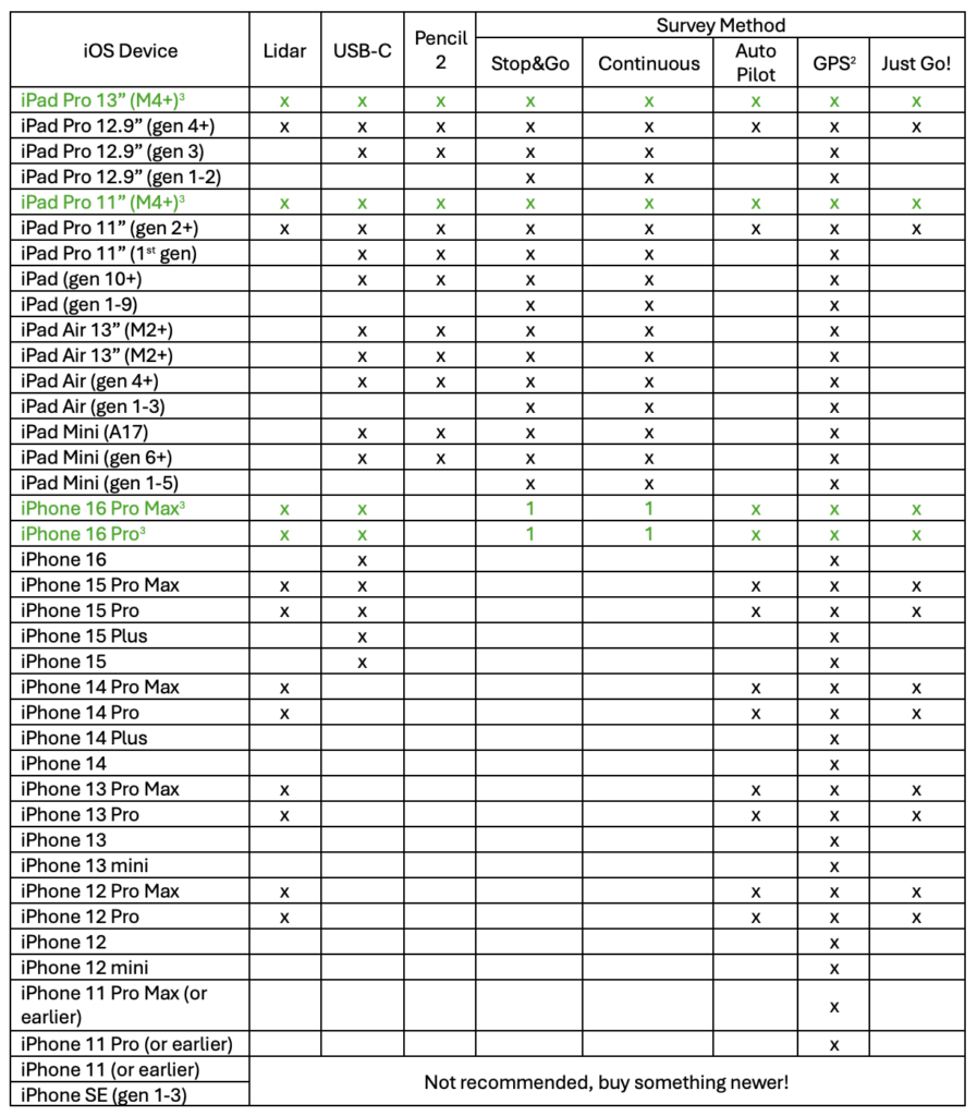
- These devices supported the identified method, but I prefer not to use them for this method due to the smaller screen size.
- Performing GPS surveys is only supported on LTE-enabled hardware versions like iPhone or iPad+LTE, while creating GPS survey projects can be done on any iOS device by integrating with Apple Maps or manually adding GPS alignment points.
- If you can’t decide, this is the one I’m telling you to purchase and get the LTE version. Get the most recent generation!
- iPhone 15 Pro & Pro Max support Wi-Fi 6E (6GHz)
- iPhone 16+ support Wi-Fi 7
- iPad Pro 11” (gen 4+) supports Wi-Fi 6E (6GHz)
- iPad Pro 11” (gen 4+) supports Wi-Fi 6E (6GHz)
- iPad Pro 11” (M4+) supports Wi-Fi 6E (6GHz)
- iPad Pro 12.9” (gen 6+) supports Wi-Fi 6E (6GHz)
- iPad Pro 13” (M4+) supports Wi-Fi 6E (6GHz)
Sure…you could purchase the lowest-cost iPad model (iPad 9th gen) for $329US for your survey goals, but it would NOT come with LiDAR, Pencil 2 support, or a USB-C port.
Slàinte!
Resources
Apple – Compare iPad models.
https://www.apple.com/ipad/compare/
Apple – Compare iPhone models.
https://www.apple.com/iphone/compare/
Wi-Fi roaming support in Apple Devices
https://support.apple.com/en-ca/guide/deployment/dep98f116c0f/web
Wi-Fi Specifications for Apple devices
https://support.apple.com/en-ca/guide/deployment/dep268652e6c/web
Cisco network enhancements for Apple devices
https://support.apple.com/en-ca/guide/deployment/dep271900868/web